Most buyers assume lakefront ownership works like a backyard fence line: you own the land, and the “backyard” continues into the water. In Central Florida, that’s usually not how it works. The view may feel private. The water may look like an extension of your lot. But legal ownership and practical control are two different things, and the gap between them is where people get surprised—usually when they try to modify a shoreline, replace a dock, or resolve a boundary dispute.
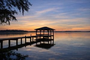 What you typically purchase is upland property that touches the water, plus a bundle of rights tied to that shoreline. Those are commonly called riparian rights (and in some contexts, you’ll also hear littoral rights for lakefront). The short version is this: in many Florida lakes, you don’t own the water behind your dock, and you often don’t own the lake bottom either. You usually own the land up to the water boundary, and you have rights of access and reasonable use—subject to regulation.
Ownership vs. Rights: The Reality Behind “My Water”
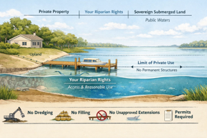
A clean way to think about it is in layers. Your deeded ownership is typically the uplands—the dry land described in the legal description. From there, the question becomes: where does private ownership stop and public ownership begin?
On many lakes, especially those considered navigable or held in the public trust, the lake bottom can be treated as sovereign submerged land. That means the State’s interest exists beneath the water. In practical terms, it’s why you can stand on your dock and still be standing over something you don’t actually own. You may have the right to cross it, use it reasonably, and improve access with a properly permitted structure—but that’s not the same thing as fee-simple ownership.
This is where buyers get tripped up: a dock does not automatically imply ownership of what’s under it. It implies permitted use, and sometimes historical use, but not necessarily title.
The Boundary That Matters: Ordinary High Water Line
For lakefront, the key concept is the shoreline boundary—often discussed as the ordinary high water line. On paper, it’s the line that helps distinguish private uplands from the water body and any sovereign interest beneath it. In the field, it’s not always intuitive. Central Florida lakes fluctuate. Drought cycles expose shoreline. Wet years push water into yards. A seawall can visually “fix” a shoreline that still has legal nuance underneath it.
If you’re buying on lakes with wide seasonal variance—parts of the Harris Chain, sections of the Winter Haven Chain, or certain Clermont-area lakes—this line matters. It’s not just academic. It influences what you can build, how far you can extend, whether you can add fill, and how permitting agencies view your proposed work.
What Riparian Rights Typically Include (And What They Don’t)
Most lakefront owners do have meaningful rights, and they’re valuable. In plain terms, riparian rights usually cover:
Access to the water from your shoreline, reasonable use of the water, and the ability to apply for a dock or lift—within agency rules and without encroaching on neighbors. That’s the “bundle.”
But riparian rights do not mean you can do whatever you want in the water. They don’t automatically allow dredging, filling, enlarging your shoreline, extending a dock to chase deeper water, or building a boathouse because the neighbor has one. They also don’t protect you from conflicts if your dock, lift, or mooring area crosses into what a neighbor can reasonably claim as their access corridor.
That difference—use vs. ownership—is the entire ballgame.
Why Permits Exist: Docks, Seawalls, Dredging, and “Minor” Work 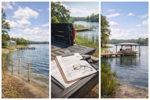
In Florida, shoreline work is regulated because it affects navigation, habitat, water quality, and public trust interests. Even when a project feels small to a homeowner, it can trigger review. Dock replacements, expansions, lifts, seawall repairs, and dredging are the usual pressure points.
The practical reality is that a typical dock plan is not just a contractor conversation. It can involve agencies and timelines. Some projects fit neatly into exemptions or streamlined permits. Others don’t—especially when you’re dealing with wetlands, aquatic vegetation, manatee protection areas, constrained canal widths, or lakes with heightened oversight.
Cost-wise, owners often underestimate the “paper” side of waterfront work. A clean baseline for budgeting in Central Florida is:
A current boundary/topo survey commonly runs $1,500–$4,000+ depending on complexity and shoreline conditions. Engineering drawings or permit-ready site plans can add $1,000–$3,500+. Dock construction itself varies wildly, but for a quality build—piles, framing, decking, hardware, lift, electric—$20,000–$80,000+ is a realistic range, and higher is common when you add covered structures, longer runs to reach depth, or premium materials.
The point isn’t to scare anyone off. It’s to keep the capital plan honest. Lakefront ownership is rarely “cheap to maintain,” and the permitting side is part of that equation.
The Neighbor Problem: Riparian Lines and Encroachment
The disputes I see most often aren’t about who owns the water. They’re about who can reasonably use it, and where one owner’s access corridor ends and another begins.
Older platted subdivisions are the classic setup. Lots were drawn decades ago, shorelines shifted, seawalls were added, docks went in “where they fit,” and over time the assumed layout becomes treated as fact. Then a sale happens. A new buyer orders a survey. A dock rebuild gets proposed. And suddenly everyone realizes the dock has been sitting in the wrong place for twenty years.
This is why a pre-closing review matters. You want to verify dock permits (or at least evidence of lawful construction), confirm setbacks and alignments, and understand whether the dock is positioned in a way that can be rebuilt if it’s damaged. A dock that exists today is not a guarantee that the same dock can be rebuilt tomorrow in the same footprint.
Central Florida Nuance: Chains, Canals, and Management District Reality
 Central Florida isn’t one uniform lake system. The Butler Chain behaves differently than parts of the Winter Haven Chain. The Harris Chain mixes wide open water with tighter corridors. Canal-fed systems add flow considerations. Lake levels can be influenced by structure operations, upstream discharge, and broader watershed management. That means your “water behind the dock” is sometimes less stable—and less personal—than it appears on a calm afternoon showing.
From a buyer strategy standpoint, the safest posture is simple: treat the water as a regulated public resource that you have valuable access to, not as acreage you own. That mindset keeps expectations aligned with how Florida actually runs its shorelines.
What I Tell Buyers Before They Close
If you want to protect yourself, the work happens before closing, not after. Confirm the boundary and shoreline conditions with a competent survey. Ask for any dock permits or records the seller has. Look at how the dock sits relative to lot lines and neighbors. If you’re planning changes—lift, extension, dredge—assume you’ll need a realistic permitting path and timeline. And don’t confuse a long-standing structure with guaranteed future rights.
Lakefront ownership comes with privilege. But it also comes with regulation. Knowing the difference is what keeps a “dream dock” from turning into an expensive lesson.